NEWS | SOFTWARE | SHEET
Types of Levelling in Surveying
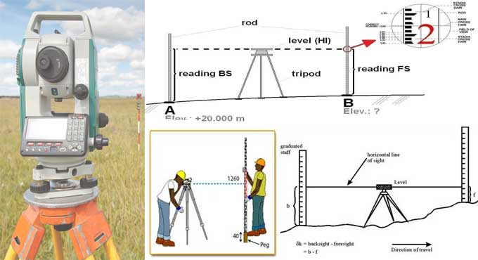
A Leveling is establishing the height of one point (or level) concerning another in surveying. It is used in surveying to determine a point's elevation relative to a datum or to determine a point's height relative to a datum. A spirit level, for example, is one of the various surveying tools that can be used, and are all those tools are loosely referred to as 'levels.'
'Level, an area,' is also used for ground preparation and excavation. That implies that the land has been leveled and graded evenly. It might get critical if work is to be done on uneven or sloping land. The phrases 'level' and 'flat' can be used interchangeably in this context, but they should be used separately in other situations.
According to civil engineering, leveling is a branch of surveying that measures the levels of several places concerning a fixed point. Such as the elevation of a building or the height of one point from the ground.
Different types of Levelling
It is the most widely used leveling procedure. Measurements are taken straight from the leveling tool in this manner. Direct leveling is classified into three forms based on observation points and instrument positions:-
Simple Levelling
The leveling instrument is positioned between the sites where elevation is to be found in this simple and basic manner of leveling. Leveling rods are placed and sighted with a leveling instrument at those spots. It can only be done when the points are closer to each other, and there are no barriers in the way.
Differential Levelling
When the distance between two places is greater, differential leveling is used. During this process, several inter stations are identified, an instrument is relocated to each station, and the elevation of inter-station points is observed. Finally, the difference between the two initial positions is calculated.
Fly Levelling
The fly leveling technique is used when the benchmark is too far away from the workstation. In this situation, a temporary benchmark is set up at the workstation based on the original benchmark's location. Even though it is not very precise, it is used to estimate the level.
Profile Levelling
In most cases, profile leveling is used to determine the elevation of points along a line, such as for roads, trains, or waterways.
Readings from intermediate stations are taken in this situation, and each station's lowered level is determined. Finally, the alignment is drawn from this cross-section.
Precise Leveling
Precise and Differential levelings are similar to each other, but precise leveling is used if you want more accuracy. In order to apply precise leveling, some serious observation techniques must be used. By the use of Precise leveling, one can achieve an accuracy of around 1mm per kilometer can be achieved.
Reciprocal Leveling
Reciprocal leveling is used when it is impossible to locate the leveling instrument between the visible sites.
For example, this situation arises in the case of ponds, rivers, and other bodies of water. The instrument is positioned closer to the first station and sighted towards the second station in reciprocal leveling.
Trigonometric Leveling
Trigonometric Leveling calculates the elevation point or the difference between the points by observing horizontal distances and vertical angles. It is a way of surveying or calculating the elevation point by its vertical angle and horizontal distance. Trigonometric leveling is also referred to as indirect leveling.
To get more clear ideas, go through the following exclusive construction video tutorial.
Lecturer: Engineer Boy
Barometric Leveling
A barometer is a device that measures the atmosphere at any altitude. As a result, atmospheric pressure is measured at two different sites in this leveling method, and the vertical difference between the two points is calculated. It's a rough estimate that's only utilized once in a while.
Stadia Leveling
The Tacheometer principle is used to determine the elevation of a spot in this modified form of trigonometric leveling. The line of sight is slanted from horizontal in this surveying technique. It is more precise and well-suited to surveying hilly terrains.


